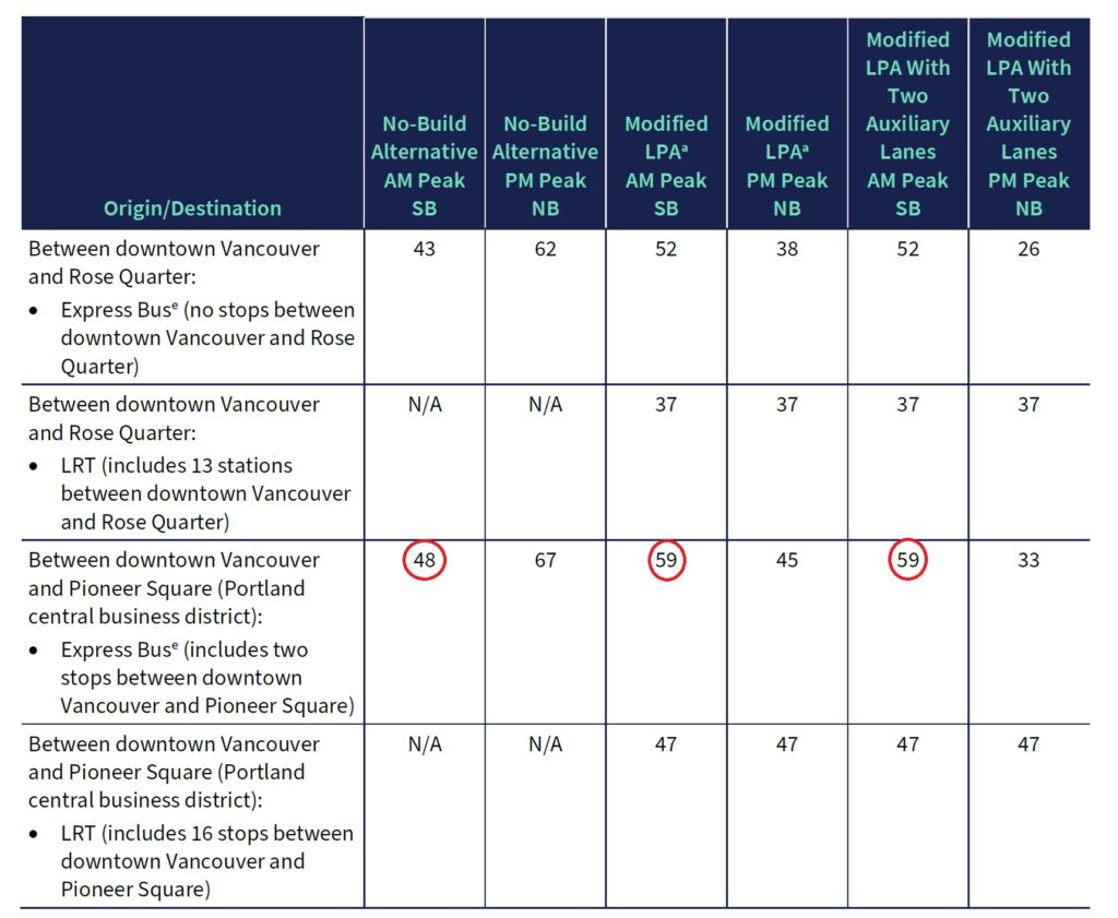
One of the surprising results in the IBR Draft Supplemental EIS (SEIS) is that the express buses running from downtown Vancouver to downtown Portland get SLOWER in the morning in the 2045 horizon year. In the no-build scenario these buses take 48 minutes. In the build scenario (aka Modified Locally Preferred Alternative or MLPA) they take 59 minutes.

This was significant enough to get called out specifically in the press conference for the SEIS release.
Meanwhile, Light Rail, even with 16 stops between Vancouver and Pioneer Square gets there in 47 minutes.
Of course, this is counter-intuitive. We’re adding at least one new lane in each direction on the bridge and express buses will be allowed to use the shoulder when there’s congestion on the bridge.
So what’s behind this? The bridge is actually not the relevant bottleneck in this equation. When traffic flows south more smoothly it bumps into the next bottleneck.
Your mind went straight to Rose Quarter, didn’t it? Well, that’s not the answer! IBR’s modelling in 2045 assumes that the Rose Quarter project has been built by then.
In fact the next key bottleneck is the I-5/I-405 split in North Portland, and that’s where express buses will sit in traffic. That bottleneck is due to folks merging in at the ramps in North Portland and then the merge/weave behavior at the split. And that bottleneck, with more traffic pushed south by removing bottlenecks north of the bridge will actually back up across the bridge!
But wait! Aren’t we using variable rate tolling to try to smooth out that peak hour congestion? We are, but it turns out that’s mostly going to impact discretionary trips. Apparently commuters are a lot less elastic in their response to pricing. The bottom line is there will be more drivers hitting the I-5/I-405 split in the morning MLPA scenario (versus the no-build) and that congestion may well back up into Vancouver as the SEIS reveals:
“but congestion in North Portland would worsen approaching the downstream I-5/I-405 bottleneck in North Portland because traffic would no longer be as constrained by a bridge bottleneck. The combined congestion from the I-5/I-405 bottleneck in North Portland plus the bridge volumes would extend back into the study area as far north as the C-D system in Vancouver between Mill Plain Boulevard and SR 14.” (SEIS Chapter 3.1, p. 27)
Does this mean commuting drivers will also face longer morning commute times? We think so, but the SEIS measures cars and buses differently. Buses are measured downtown-to-downtown. Auto travel times are reporting in the SEIS from I-205 in Vancouver to I-405 in Portland, which obscures this effect to some degree.
Here’s a remix of charts from the SEIS describing the southbound AM traffic (to be clear, this is 100% IBR info, we just put them side-by-side, which the SEIS does not) that spell this out:

The timing and location of the congestion changes a bit, but mostly it’s still there. Somebody’s going to be disappointed about what $5-8B is buying! [To be fair, the return commute in the afternoon does appear to be somewhat improved.]
What lessons do we take from this? Maybe somebody should be thinking about managing the system, rather than chasing each bottleneck? Thoughtful congestion pricing throughout the corridor could yield very different results. Meanwhile we’ll watch for ODOT to propose the next multi-billion dollar bottleneck project, got to keep the Freeway Industrial Complex busy…
You are not taking into account the potential # of people out of cars and into the Max when you make your statements about lower transit. Does their analysis include the reduction of peak commuter cars in the congestion on the bridge?
Sadly there is only 700 new parking spots at the new Max station in downtown Vancouver. They claim another 520 in mixed use nearby but that’s hard to believe. Do you know about that info?
Thanks for your hard work on this.
The congestion assumptions (from the EIS) analyzed above DO assume that a significant number of folks shift from driving to Light Rail. They are considering Park and Ride lots at both the Evergreen and Waterfront stations in Vancouver.
So you organization would rather keep a 100 year old bridge with wood piles in a spot or the columbia that is slowly shifting and letting the bridge sink into silt eventually? Whats your solution? This has been talked about for two decades, we need a replacement. It will 10 plus years of good paying union construction jobs to the area and most importantly build a bridge that’s safe for the next 100 years of travel. What does your organization want? Perfection? These are models, estimations, not exactly predictions of the future. You seem adversarial, picking apart shit because it doesn’t fit or check every single block. Also what does a bridge replacement have to do with social justice? Please explain that mission statement.
We support the seismic replacement of the bridge, although it could be designed for more effective transit and active transportation functioning. It’s the other four miles of freeway expansions that we’re mostly concerned about.